Technology choices we make can make or break your web application. Here are a few things I’d like to share based on my experience as a web developer. 1. Programming language Not all programming languages created equal. This is especially true when we talk about ASP aka “Classic ASP”. Microsoft stopped developing ASP back in 1999. Once a modern and extensible web programming language it is now a dinosaur trying to compete with spaceships. Every new release of IIS makes configuring ASP more difficult. It…Continue Reading “Technology choices”
Experienced developers won’t find anything in this article they didn’t know already. All others will find it quite useful. We’ll show a few different ways of how you can quickly test the mobile version of your application.
This article applies to PHPRunner, ASPRunnerPro and ASPRunner.NET with Mobile template option enabled.
1. Using your web browser
All modern browsers have an option to show any page the way it will appear on mobile device. In this article will show you how to do this using Chrome web browser.
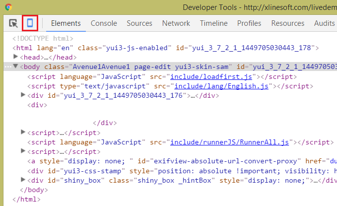
1.1 Hit F12 to open Chrome Developers Tools. Click Mobile device icon in Chrome Developer tools.
You need to change some field labels in your project but don’t want to rebuild and upload the whole project. In this tutorial, we’ll show how to do that by storing field labels in the database and displaying them dynamically. As a bonus, we’ll also show how to hide fields based on visibility rules stored in the database, and make fields read-only or required.
First, we need to create a table in the database to store all those settings. We would need fields like table name, field name, field label and visibility. Here is the sample table script for MySQL.
The code in this article was updated to be compatible with version 10.x of PHPRunner, ASPRunner.NET and ASPRunnerPro.
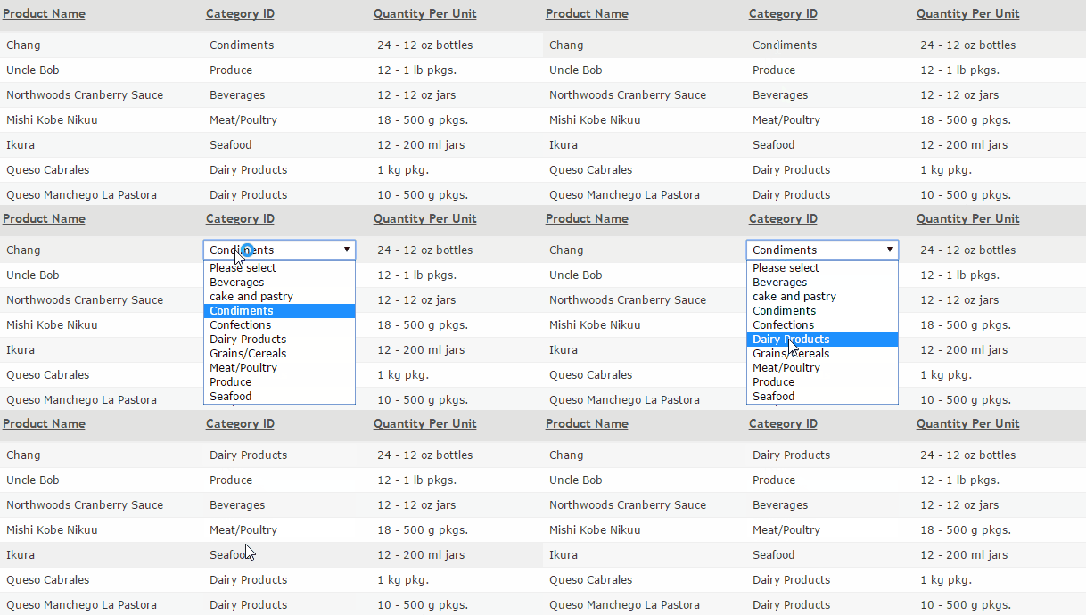
Similar to Excel-like grid discussed in previous article this technique helps you to achieve similar goals. Instead of bringing up the whole edit page you can click that single field you need to edit, change its value and see your changes posted to the database automatically.
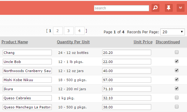
Some applications may require to provide users with quick editing capabilities. While Inline Edit does just that entering inline edit mode for multiple records can be painful. It would be much easier is some or all fields appear as edit controls when page is loaded.
While PHPRunner/ASPRunner.NET/ASPRunnerPro do not have such functionality built-in it’s fairly easy to implement it in your project. In this sample project we’ll show how to make fields ProductName, UnitPrice and Discontinued editable automatically. For now we only support text boxes and check boxes. Data is saved automatically once you leave the text box or check off check box. To see that data is actually saved in the database simply reload the page.
You can also see how server-side validation works. Enter Unit Price that is less than $20 and move to the next field to see it in action. Record won’t be saved until you enter $20 or more price value.
In recent Using Google Docs Viewer to preview documents online article we reviewed the use of Google Docs Viewer for document preview purposes. While this is a viable approach two main concerns arise:
- dependency on third party service
- security issues
For those who is looking for another solution there is a brilliant Javascript library named ViewerJS that supports PDF files as well as Open Office formats (.odp, .odt, .ods). This library can display documents right in the web browser, no need to install any additional software. Documents can be displayed either in full page mode or embedded into other pages. See some examples.
Continue Reading "Adding PDF preview support to your web application"The latest version of Runner family products comes with several improvements in mapping area like support of Bing and OpenStreet maps, maps in dashboards, custom map markers etc. In this article I want to show a couple more mapping features that you can use in your apps, heat maps and clustered maps.
Both those features can help you visualize large amounts of mapping data. It gives your users a better insight on your data. For instance, those maps tell you that if you are a taxi driver in NYC, your chances to pickup a passenger are higher if you are nearby Trump Tower.
Continue Reading "New mapping features"Great news! PHPRunner 8.1, ASPRunnerPro 9.1, ASPRunner.NET 8.1 released. Grab your copy now.
PHPRunner 8.1
ASPRunner.NET 8.1
ASPRunnerPro 9.1
Mobile template v2
Upgrade from previous version of Mobile template $25
Here is the list of new features in this update.
Free-form design mode
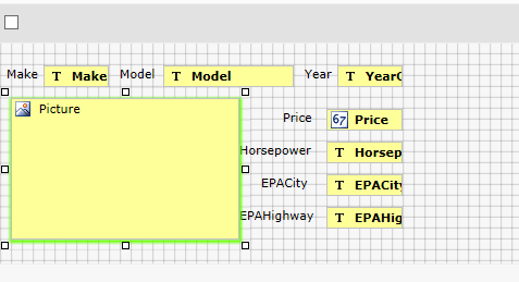
You are no longer required to use HTML tables to arranger fields on Add/Edit/View forms. Turn on free-form mode and drag-n-drop fields and labels where they need to be. This mode is available on Add/Edit/View pages and also on List page in vertical mode.
This is an example of List page edited in free form mode.
Google Docs Viewer provides an excellent option to preview Office documents online. No need to download them to end user machine, no need to have any Office software installed. Supported formats are Microsoft Word, Microsoft Excel and PDF.
Continue Reading "Using Google Docs Viewer to preview documents online"PHPRunner 8, ASPRunnerPro 9 and ASPRunner.NET 8 added an option to use multiple database connections in single project. This article explains how you can access data from multiple databases in your events.
![]()
